

It’s no secret that there’s a lot of guesswork involved in oil production. Oil companies make “Big Money” decisions based on estimates – estimates with huge margins of error. What’s more, there is an incredible amount of risk involved, but with the potential for a large pay-off if all goes according to plan. The plan is based on “best guesses” and less than perfect data. Still, there are many big players in the oil industry that are doing very well in this area. All based on estimates made by engineers.
Where Is the Oil?
There are many question marks in the oil industry. When prospecting for oil, companies need to answer questions like “Where are the reserves located?” and “How much oil is in the reserve?” You won’t know the true answer to this until after you’ve depleted the reserves and by then that information is no longer useful for prospecting purposes. So how do they do it? One thing they don’t do is use trial-and-error. With enormous costs associated with oil and gas drilling, estimates need to be well calculated. Although they cannot be 100% accurate, due to the nature of the work, they at least need to be “close enough”.
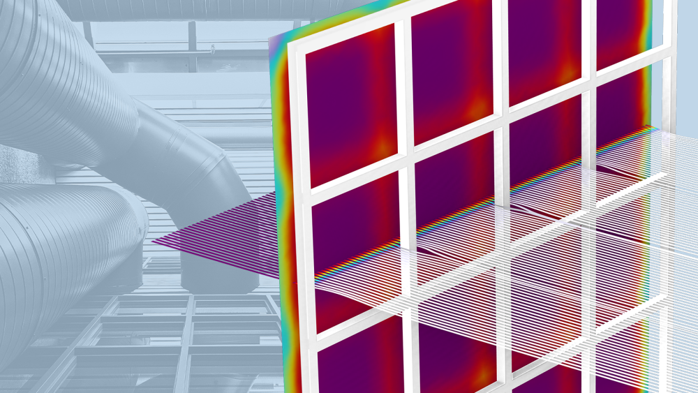
One technique used for oil prospecting out at sea is called the “Marine Controlled Source Electromagnetics Method” (CSEM). By towing a mobile horizontal 1Hz electric dipole antenna 150 meters above the sea floor, receivers can measure the electric field between the sea floor and the antenna. If a reservoir is present, the signal will be noticeably higher. This is because at larger distances, the energy transmitted from the antenna is reflected and guided by the resistive reservoir.

Model of an electromagnetic sounding method for oil prospecting. The model represents a sphere with a 5 km radius with the top representing air. Below the mid plane there is a 1.5 S/m conductivity and a relative permittivity of 30 for the rock. 150 meters above the mid plane, the transmitter is modeled as a short 10 kA amplitude AC line current segment. At the external spherical boundaries, a scattering type boundary condition absorbs outgoing spherical waves. The red spot in the center is the electric field magnitude containing the antenna. The guiding effect of the hydrocarbon layer is shown.
Safe Drilling
Assuming the prospecting stage went according to plan, moving on to the actual production process brings more questions to the surface. One of those may be “Will the drilling cause the earth around the wells to collapse?” Engineers out in the field will need to pay close attention to the pressure levels underground in order to prevent the ground from collapsing.
This is especially the case when engaging in multilateral drilling. Above, we mentioned a technique used for finding oil, but when optimizing the actual production process, deep wellbores are often constructed with multiple branches to lead the oil to the surface. With many wells running through the ground, the oil production can be maximized, but at the risk of collapse, unless mechanically stabilized. In order to estimate the pressure and total displacement due to pumping, engineers can run simulations using the Subsurface Flow Module.

Model of an open-hole multilateral well showing the pressure gradient and total displacement as a result of pumping for oil near a branch in the well.
In order to attempt to justify this high-risk endeavor, businesses work with estimates that have large margins of error. Computer modeling can be very advantageous in the analysis and optimization stages of oil production. With strong simulation tools, engineers can provide business folks with more reliable analyses. This will then lead to better business decisions.
Further Reading
Oil & Gas Models:


Comments (2)
Bernt Nilsson
October 26, 2012Another method to precisely locate the well is by using induction logging. A great example of this comes from Baker Hughes, see http://www.comsol.com/stories/bakerhughes_modeling_tools_reservoir_navigation/full/
Fanny Littmarck
October 26, 2012That is indeed a great example, thanks for pointing to the story.